AREN Project
NASA Science Activation's AEROKATS and ROVER Education Network (AREN) Project. Led by Wayne RESA that equips students and educators to do authentic Earth-science investigations.
Learners design and fly instrumented kites (AEROKATS) and operate instrumented land/water ROVERS to gather local environmental data, then analyze and share results using NASA-aligned tools in partnership with the GLOBE Program. It's rooted in a Wayne RESA and NASA Wallops pilot that began in 2010 and expanded under a NASA Cooperative Agreement in 2016. AREN blends NGSS-aligned curriculum, mission operations, and safety practices to build STEM identity and real research skills.
The AREN Project is coordinated by Wayne RESA, supported by the NASA Science Mission Directorate under Cooperative Agreement Number NNX16AB95A.
NASA AREN Project
The NASA AEROKATS and ROVER Education Network (AREN) is a Science Activation initiative led by the NASA Goddard Space Flight Center/Wallops Flight Facility. AREN engages students and educators in hands-on Earth science research using innovative, low-cost technologies. Participants utilize kite-borne sensors (AEROKATS) and robotic platforms (ROVERS) to collect real-world environmental data, fostering skills in remote sensing, data analysis, and engineering design. This experiential learning approach aligns with NASA's mission to inspire and educate the next generation of scientists and engineers.
AEROKATS
Advancing Earth Research Observations with Kites and Atmospheric/Terrestrial Sensors (AEROKATS) is a NASA/Goddard Space Flight Center research and development program that focuses on the use of kite-borne remote sensing and in situ atmospheric sensor systems for Earth systems observation and research.
ROVERS
ROVERS (Remote Observation and Versatile Environmental Research Systems) is a NASA/Wayne RESA initiative within AREN that uses land- and water-based robotic sensor platforms to collect environmental and Earth systems data for research and classroom investigations.
AREN Model
AEROKATS and ROVER Education Network (AREN) Model
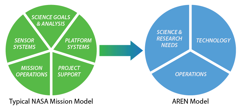
The AREN model is distilled from a typical NASA Mission Model for use in a broader educational and research environment. Notably, Sensor Systems and Platform Systems have been combined into Technology, and Mission Operations and Project Support have been grouped into the broader category of Operations.
Team & Participating Institutions
Team and Participating Institutions/Organizations
The core operational and instructional team includes engineers and educators from NASA Goddard and Wallops Flight Facility working alongside Wayne RESA staff.
Core Team Structure
The AREN initiative is part of NASA’s Science Activation (SciAct) portfolio, led by Wayne RESA, with oversight by SciAct leadership, including Kristen Erickson (NASA HQ) and Lin Chambers (NASA Langley). The team guides curriculum design, NGSS alignment, educator training, safety procedures, and integration with the GLOBE Program.
Core Leadership Team
Wayne RESA (Regional Educational Service Agency) is the project lead for AREN, operating under NASA’s Science Activation Cooperative Agreement (CAN # NNX16AB95A). This team guides curriculum development, NGSS alignment, mission training, and integration with the GLOBE Program, and includes Scientists and educators from:
- NASA’s Goddard Space Flight Center
- Wallace Flight Facility
- Wayne RESA staff
Key collaborators and Institutional Partners
AREN's impact is amplified by collaborations with numerous institutions nationwide. According to NASA’s leadership table, the program is rooted at Wayne RESA, though specific partner names are outlined in program materials and broader SciAct context.
These partners joined forces with AREN in a TerraROVER training initiative in July 2021, in collaboration with GLOBE Mission Earth (GME). The training involved providing TerraROVER units to teachers for hands-on data collection, including GPS, temperature, and humidity measurements.
University of Toledo (OH)
Defiance College (OH)
Northern Michigan University (MI)
SUNY Fredonia (NY)
Wayne RESA (MI) — notably, TerraROVER systems were assembled by Wayne RESA’s own James Moon-Dupree
Sources: NASA Science, partnerships.gsfc.nasa.gov, ciencepartnerships.gsfc.nasa.gov
Funding & Partners
Funding & Strategic Support – AREN Project
AREN is funded through NASA’s Science Activation Cooperative Agreement, with Wayne RESA and partner institutions supporting materials, training, and hands-on STEM experiences.
The AREN initiative is funded primarily through NASA’s Science Activation Cooperative Agreement (CAN # NNX16AB95A), which continues with a 2025 allocation of $477,341 for aeronautical support and training.
Wayne RESA supplements this via Board-approved purchases—allocating $50,000 each in 2023 and 2024 to Into the Wind for procurement of AREN materials and kits.
The program’s reach is furthered through collaborations with institutions like the University of South Florida, University of Alaska Fairbanks, UMES, and others, who contribute equipment development, curricular integration, and field-based enhancements for AREN’s educational tools.
Primary Funding
NASA Cooperative Agreement (CAN # NNX16AB95A): Wayne RESA has been the primary recipient and lead under this multi-year agreement, consistently receiving funding into at least 2025, as confirmed in Board Highlights. The 2025 continuation allocates $477,341 to support AREN’s activities, including aeronautical training and materials for learners of all ages.
Wayne RESA Board Support
Equipment & Supplies:
In 2024, Wayne RESA authorized up to $50,000 for purchases from Into the Wind to support AREN’s materials and kits.
Earlier, in 2023, another $50,000 was similarly allocated to Into the Wind for materials tied to the AREN grant.
These allocations highlight the board’s commitment to funding the tools and infrastructure necessary for classroom missions and educator workshops.
Collaborative Partners (Beyond Core Team)
Although distinct from institutions involved in program execution (covered earlier), these partners contribute to funding or support for specific components or expansions of AREN:
University of South Florida: Developed an engineering mentoring program enabling middle school students to design and build ROVERs.
University of Alaska, Fairbanks: Incorporated aspects of AREN into Arctic environmental education initiatives.
Chesapeake Bay Environmental Center, Anasphere Inc., Montana State University, Public Lab, and Washington College: Provided support for education tool development and operational scaling.
University of Maryland Eastern Shore (UMES): Collaborated on ROVER watercraft development at NASA Wallops, with implications for AREN’s in-water data collection tools.
Sources: Wayne RESA Board Highlights (Feb. 20, 2025), Cloudinary, Tech Briefs
Objectives
Objectives
Empower educators and students to use NASA-inspired tools to study their own environments.
Provide equitable access to STEM opportunities through hands-on flight missions, rover operations, and authentic data analysis.
Connect learning to NASA science by integrating with the GLOBE Program and sharing findings with the broader research community.
Build lasting STEM identities by helping students see themselves as problem solvers and contributors to real-world science.
History
2010: Wayne RESA + NASA Wallops pilot ICCARS; students begin flying AeroPods to study local environments.
2012: NASA patents AeroPod stabilizer for kite-borne sensors.
2016: NASA awards CAN # NNX16AB95A; ICCARS scales into AREN under Wayne RESA leadership with national partners.
2018–2024: AREN materials and programming continue across Wayne County; board records show ongoing purchases and NASA funding. ,
2025: NASA SciAct page confirms current scope, training focus, and GLOBE integration; RESA’s site publishes the AREN model.
Wayne RESA AREN Project Contacts
Featured Missions & Mission Mapper
Representative Missions
AREN missions have ranged from classroom kite flights to more specialized applications:
Volcanic plume sampling: AeroPods were flown over Costa Rica’s Turrialba volcano to test sensing equipment meant for volcanic emission studies; later iterations moved to drone deployment
Methane sensor trials over landfills: AeroPods were used to fly prototype methane sensors above a landfill in Sacramento, illustrating rapid deployment for environmental monitoring.
Photography and transects: Simple action cameras attached to AeroPods capture transect-style aerial imagery—useful in observing shoreline changes, mapping invasive species, or landscape shifts over time.
These missions not only demonstrate AREN’s technical flexibility but also model how students can engage in real-world scientific inquiry using accessible tools.
Source: partnerships.gsfc.nasa.gov
AEROKATS Mission Mapper
The Mission Mapper is a central component of AREN—it's a web-based mapping tool where participants upload and visualize data collected from AeroPod and Rover missions.
According to publications, AREN has facilitated “dozens” of AeroPod missions across the country, all tracked via Mission Mapper. The user interface allows educators and students to submit flight data, overlay imagery on interactive basemaps, and manage mission layers—supporting broader engagement and spatial analysis.
Key Technologies
AEROKATS
![]()
AEROKATS – (Advancing Earth Research Observations with Kites and Atmospheric/Terrestrial Sensors)
Aeropod: Aerodynamically stabilized instrument platform
The Aeropod is a NASA-designed, low-altitude remote sensing platform designed for environmental research purposes. The Aeropod is a passive device that uses aerodynamic forces to stabilize an instrument package suspended from a kite or tethered balloon. Aeropods can be used for a variety of remote sensing and remotely captured in-situ (in place) observations.
Benefits:
- Lightweight, simple to construct, and has no moving parts.
- Useful for a variety of remote sensing and in-situ observations.
- Able to accommodate many different-sized instruments.
- Offers a low-cost alternative to other remote sensing and observation techniques.
The basic Aeropod design consists of a payload, a boom, fins for dampening motion, and a pylon to suspend the Aeropod from a kite line.
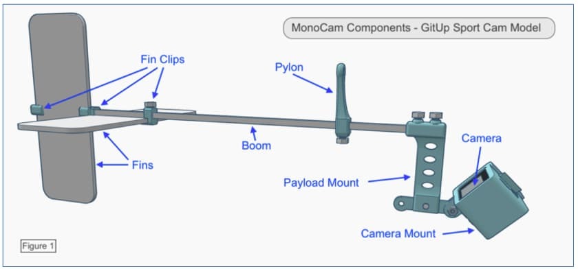
A technical diagram showing MonoCam components for the GitUp Sport Cam model. It includes a horizontal boom with fins attached on the left using fin clips, a vertical pylon near the center, and a payload mount on the right holding a camera mount and tilted camera. Labels point to each part: Fin Clips, Fins, Boom, Pylon, Payload Mount, Camera Mount, and Camera.
Aeropods can be designed with a variety of payloads to address myriad research interests. They have been used to monitor crops and agriculture, land cover and land use, invasive species, volcanic gases, conduct atmospheric profiles, and much more.
In the AREN project, they are largely used for capturing aerial imagery for monitoring land cover and land use, invasive species, vegetation monitoring, and atmospheric profiling.
Examples of the most commonly used Aeropods in the AREN project include:
MiniCam Aeropod
A lightweight, introductory aerial imaging system using a small spy camera. This is a good option for novices and can be used with smaller kites than other Aeropods. 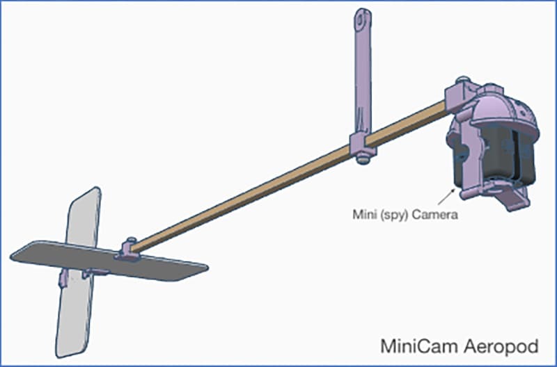
A technical diagram of the MiniCam Aeropod. It features a horizontal boom with fins attached at the left end and a vertical support near the center. On the right end, a camera is mounted using a bracket labeled ‘MiniCam Camera.’ The design shows a streamlined structure for aerial mounting.
MonoCam Aeropod
An aerial imaging system using a sports camera (similar to a GoPro). This system provides higher-quality imagery than the MiniCam but also requires a larger kite.
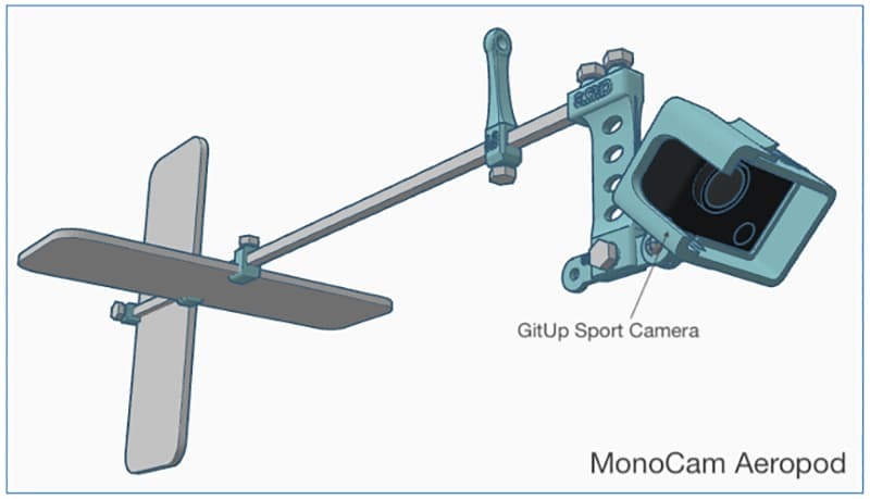
A technical diagram of the MonoCam Aeropod. It features a horizontal boom with fins attached at the left end and a vertical pylon near the center. On the right end, a GitUp Sport Camera is mounted on a bracket with multiple holes for adjustment. The design illustrates a streamlined aerial mounting system.
TwinCam Aeropod
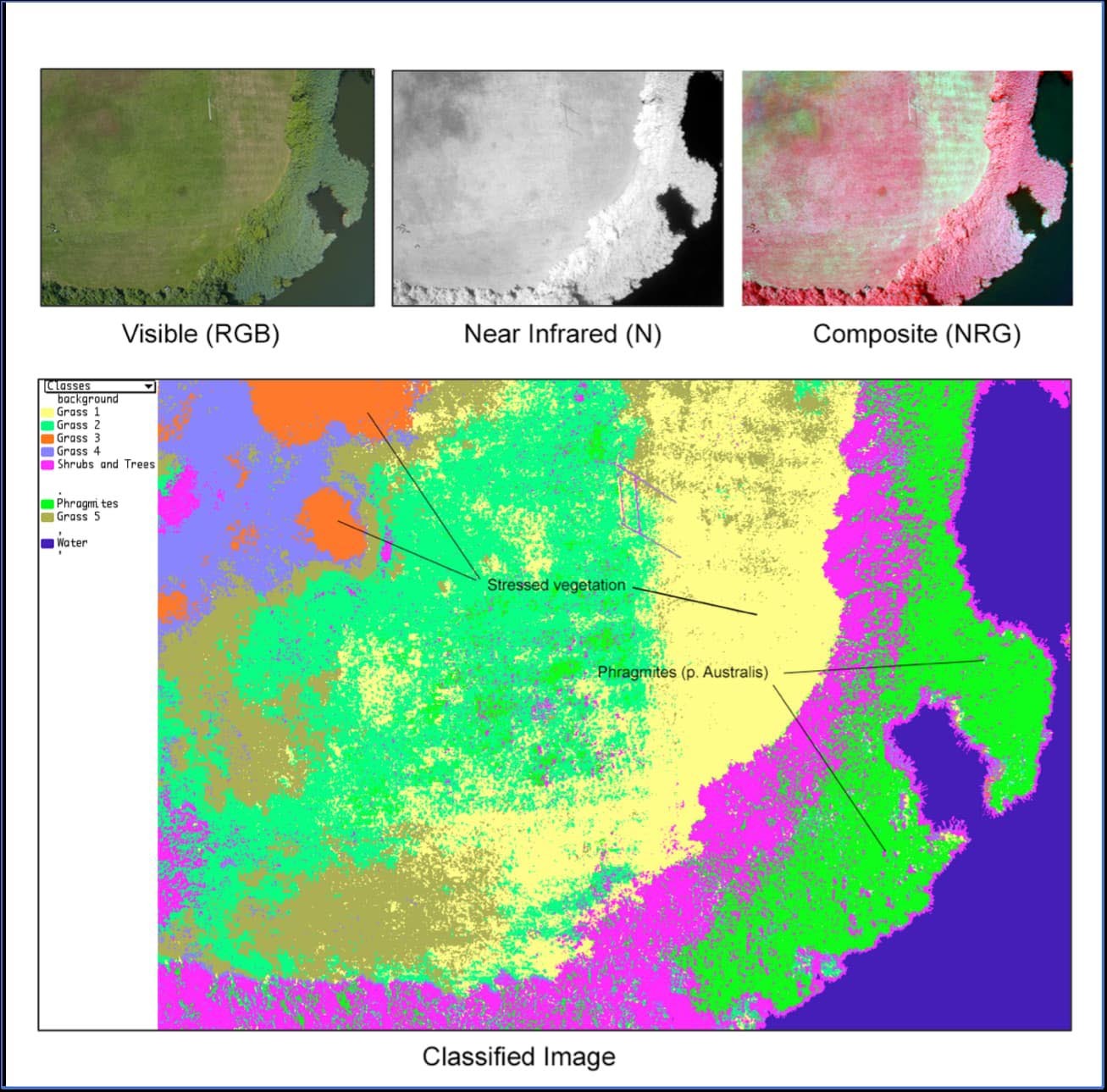
A multispectral imaging system that uses two cameras to collect both visible and near-infrared imagery. The imagery can be combined in software to produce estimates of photosynthetically active vegetation, classified land cover images, and more. This system is for more advanced users and requires a large kite for lift.
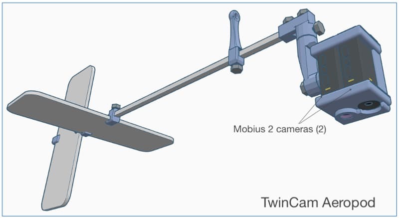
A technical diagram of the TwinCam Aeropod. It features a horizontal boom with fins attached at the left end and a vertical pylon near the center. On the right end, two Mobius cameras are mounted on a bracket labeled ‘Mobius 2 cameras (2).’ The design illustrates a dual-camera aerial mounting system for capturing multiple angles.
There are many other Aeropod designs ranging from entry-level use to advanced research platforms.
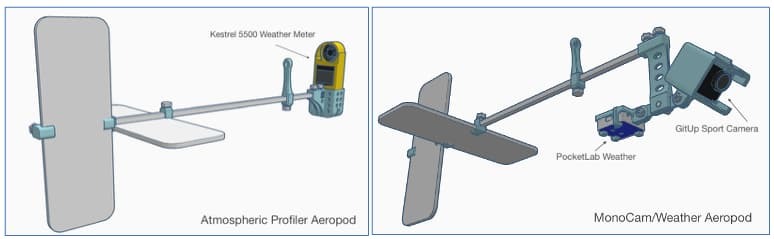
The image shows two technical diagrams side by side. The left diagram is labeled ‘Atmospheric Profiler Aeropod’ and features a horizontal boom with fins on the left end and a Kestrel 5500 Weather Meter mounted on the right end near a vertical pylon. The right diagram is labeled ‘MonoCam/Weather Aeropod’ and includes a similar boom with fins on the left, a vertical pylon near the center, and a GitUp Sport Camera mounted on the right end along with a PocketLab Weather sensor beneath the boom. Both designs illustrate aerial mounting systems for weather and camera instrumentation.
Please note: The Aeropod is a patented NASA technology (Patent # US 8,196,853 B2) and requires a license to use or make. Participants in AREN workshops are included in the AREN Project license. Individuals who would like to make or use Aeropods on their own can apply for a free evaluation license at: https://technology.nasa.gov/patent/GSC-TOPS-10
The AREN Project trains participants to safely conduct Aeropod missions and to process and analyze the data they collect. A variety of data analysis tools are employed to address a wide range of skill levels from upper elementary through university-level research.
Examples of Aeropod data products
Examples of Aeropod data products
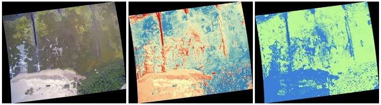
Green Leaf Index created with MonoCam Aeropod imagery and QGIS software
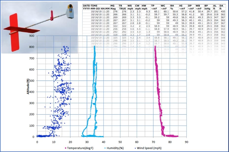
Atmospheric Boundary Layer Profile using Profiler Aeropod data and MS Excel software
Twin Cam Image Processing - Classification Example
Invasive Species Detection using TwinCam imagery and MultiSpec software.
KITES and Tethered Balloons
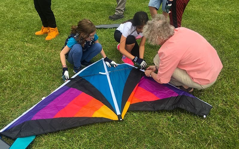
Aeropods are designed to be carried aloft by kites or tethered balloons. Individuals with experience using tethered balloons and blimps have used Aeropods for research purposes. These are often professionals or researchers in university settings. For the AREN Project, the focus has largely been on kite-based systems for simplicity and reaching a broad audience.
Aeropod performance is best in light to moderate winds. Large (7 – 9 ft wingspan) Delta and Delta-Conyne style kites are ideal for lifting in light winds. As a result, those are the primary kite styles employed in the AREN Project. For moderate winds, large parafoil-style kites can also perform well. The AREN Project also uses small sled-style kites called Frustrationless Flyers for training.
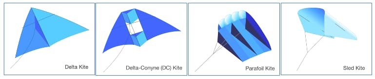
AREN partners with Into the Wind to provide kites for the project. The kites most utilized for carrying Aeropods in the AREN Project have been:
- ITW 7ft Levitation Lite (A delta kite for lifting smaller Aeropods in light to moderate winds)
- ITW 9ft Levitation Lite (A delta kite for lifting larger Aeropods in light winds)
- ITW 10ft Alpine DC (A delta-conyne kite for lifting larger Aeropods in light winds)
- ITW 10ft Parafoil (A parafoil kite for lifting larger Aeropods in moderate winds)
- Frustrationless Flyers (A small sled kite that can be built and decorated by students. Used for training)
Kites from other manufacturers and in other styles can be used as well, and experimentation is welcome!
TerraROVERs
![]()
ROVER (Remotely Operated Vehicle for Environmental Research)
ROVER (Remotely Operated Vehicle for Environmental Research)
ROVERs extend AREN’s experiential learning by allowing remotely collected measurements of environmental phenomena in terrestrial (TerraROVER) and aquatic (AquaROVER) environments. For TerraROVERs, these include surface and air temperature, relative humidity, albedo, aerosols, and more. AquaROVERs are used to gather water quality data, such as temperature, pH, dissolved oxygen, salinity, and additional parameters.
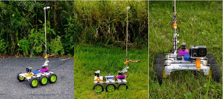
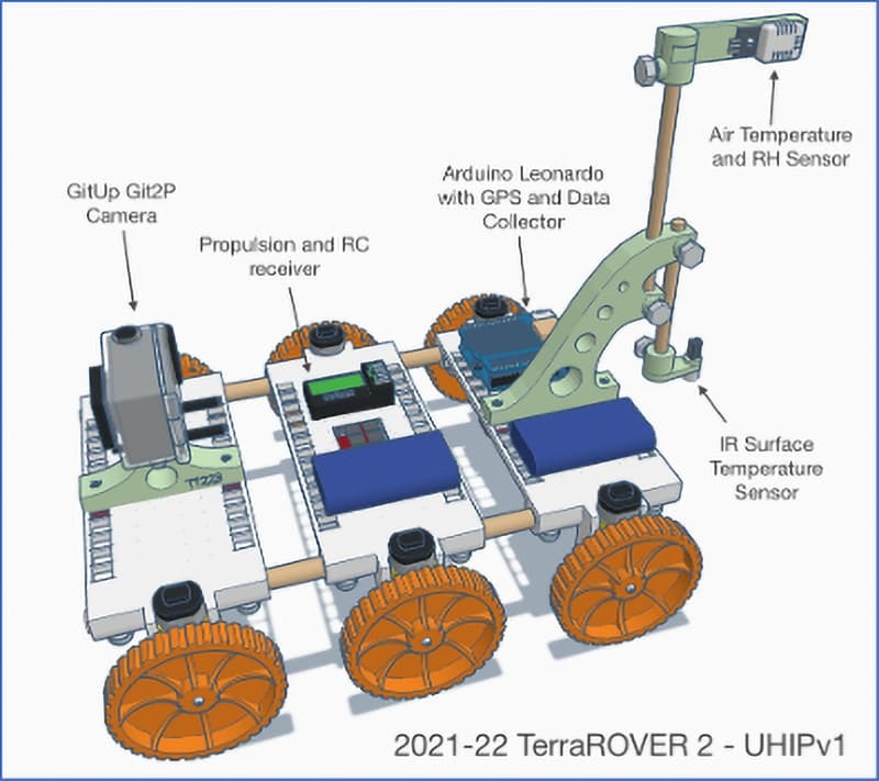
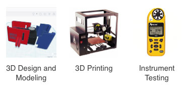
TerraROVER: A NASA-designed remote-controlled vehicle introduced in 2021 for collecting remote measurements of surface material and other near-ground-level environmental phenomena. The TerraROVER consists of a remote-controlled terrestrial vehicle and an instrument package for collecting measurements. The craft is customizable and able to accept a variety of instrument packages.
Please note: The TerraROVER platform is a patent-pending NASA technology and requires a license to use or make. (Participants in AREN workshops are included in the AREN Project license.) Individuals who would like to make or use TerraROVERs on their own can apply for a free evaluation license at: https://technology.nasa.gov/patent/GSC-TOPS-387
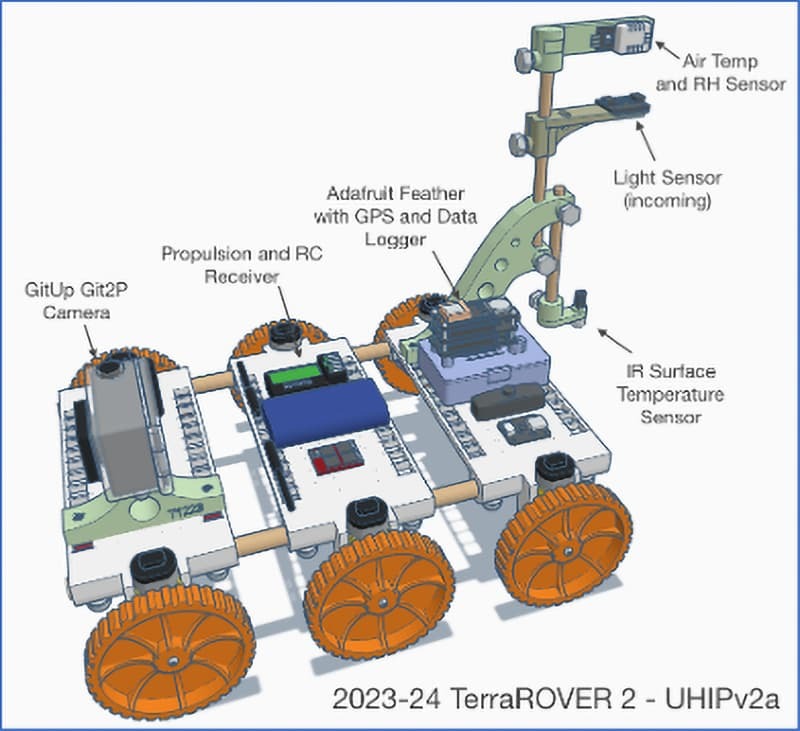
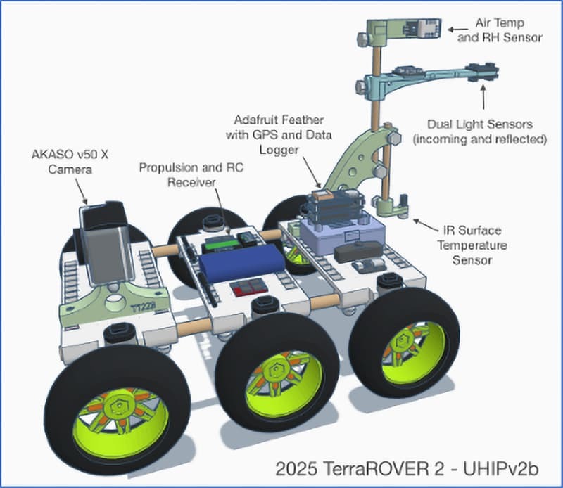
The AREN project developed the Urban Heat-island Instrumentation Package (UHIP) to be used for studying the variability of absorption and reflection of incoming solar radiation by different land-surface materials. All production versions of the UHIP (2021-2025) include a thermal infrared surface temperature sensor, an air temperature and relative humidity sensor, and a GPS receiver. These are integrated into an Arduino-based controller and data collector. The 2023-24 model included a light sensor for detecting incoming solar radiation, and the 2025 version includes a second light sensor pointed at the surface to collect reflectance values. The UHIP collects a datapoint every 2-3 seconds, and the data sets can be processed in a variety of tools, including spreadsheet programs, CODAP, and geographic information systems (GIS).
TerraROVER and UHIP Production Models used in the AREN Project:
TerraROVER 2021-2022 Features:
- 3D printed wheels, decks, and sensor mounts
- Arduino Leonardo-based UHIP sensor package
- GPS
- Infrared surface temperature sensor
- Air temperature and relative humidity sensor
- GitUp Git2P Camera
TerraROVER 2023-2024 Features:
- 3D printed wheels, decks, and sensor mounts
- Adafruit Feather-based UHIP sensor package
- GPS
- Infrared surface temperature sensor
- Air temperature and relative humidity sensor
- Light sensor (incoming)
- GitUp Git2P Camera
TerraROVER 2025 Features:
- Commercially produce rubber wheels,
- Commercially manufactured decks,
- 3D printed sensor mounts
- Adafruit Feather-based UHIP sensor package
- GPS
- Infrared surface temperature sensor
- Air temperature and relative humidity sensor
- Dual-light sensors (incoming and reflected light)
- AKASO v50 X Camera
Additional instrumentation is in development with added capabilities, such as thermal imaging, ground-level aerosols (PM2.5) and CO2 monitoring, and more. Users of TerraROVERs are encouraged to develop their own instrument packages to suit their research needs as well.
The AREN Project trains participants to both operate the TerraROVER and to process and analyze the data it collects. A variety of data analysis tools are employed to address a wide range of skill levels from upper elementary through university-level research.
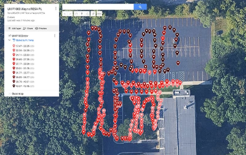
Examples of TerraROVER Data
Examples of data products
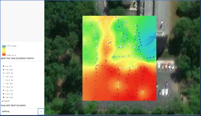
UHIP Surface Temperature Data Plot: Google My Maps
UHIP Data Plot Analysis and Mapping: CODAP
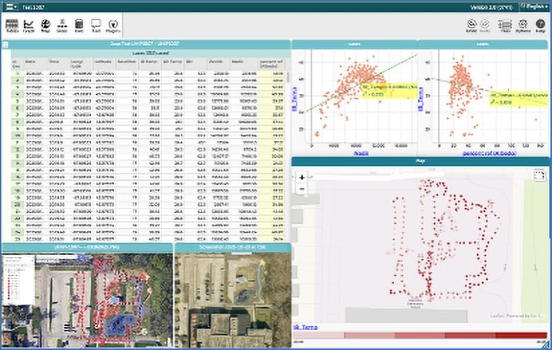
UHIP Surface Temperature Plot: QGIS
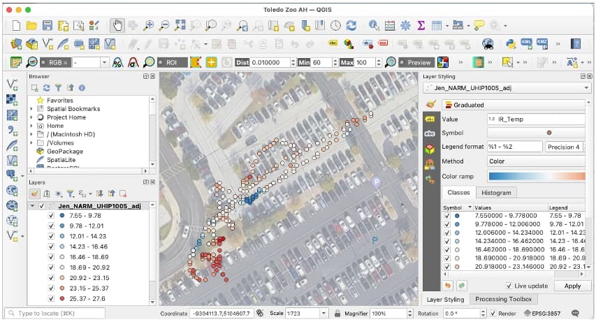
Interpolated Surface Temperature: ArcGIS Online
AquaROVERs
AquaROVER
AquaROVER: A NASA-designed remote-controlled aquatic craft for collecting remote water quality measurements. The AquaROVER includes a Vernier Instruments data acquisition package for collecting measurements of various water quality parameters.
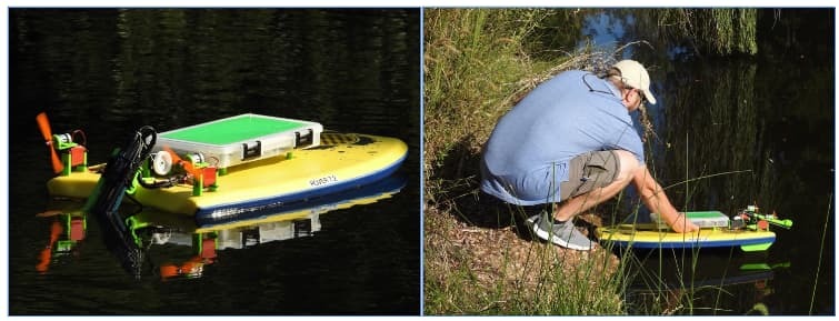
AquaROVER version 7.2 Deployment
The AquaROVER Platform was deployed in a limited number of settings. Due to supply chain issues and the complexity of the system, AquaROVER was never brought to scale during the project. It continues to be used for water quality evaluation in select settings, but there is no plan to resume production at this time.
Please note: The AquaROVER is a patented NASA technology (US-Patent-10,059,418). A license is required to produce or use this platform. Patent information can be found here: https://ntrs.nasa.gov/citations/20180005310.
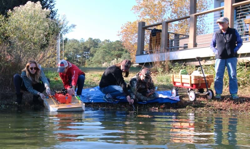
Students at Chesapeake Bay Environmental Center with AquaROVER 4 prototype
Examples of AquaROVER Data Products
AquaRORVER Example Dataset
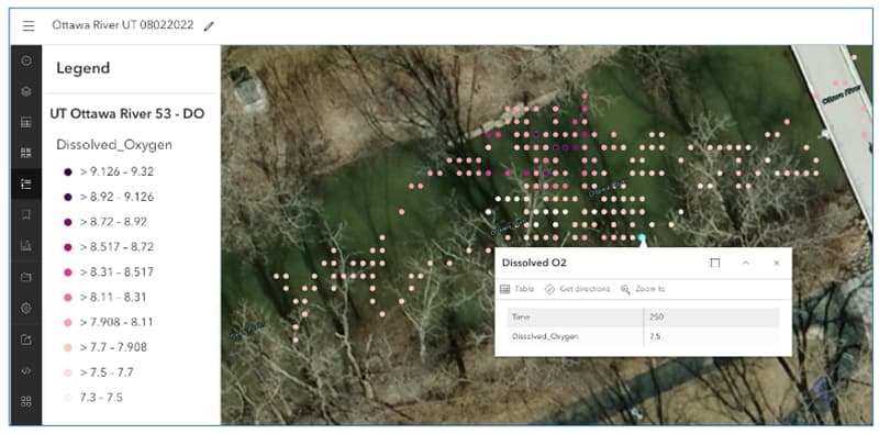
Dissolved Oxygen Plot on Ottawa River, Toledo, OH with AquaROVER data and ArcGIS Online
Science + Art
View Information and Examples
 Atmospheric Sounding
 Atmospheric sounding collects a vertical profile of the atmosphere to study different phenomena and the meteorological forces that affect the weather.
 Earth Observations
 Earth observations encompass the study of all the Earth’s systems. The AEROKATS program utilizes remote sensing to study aspects of a more local environment.
 Engineering
 Engineering is the science that enables the project to continually improve and be highly versatile, adapting the Aeropod to carry different instrumentation that fits various research needs.
 History + Art
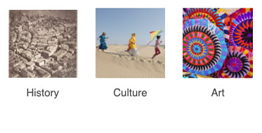
 Kites have been flown culturally for many centuries and have been used for data collection as far back as aerial imagery has been available, dating back to the early 1900s.
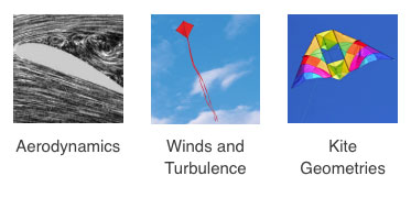 Kite Dynamics
 The design and construction of kites and Aeropods, as well as their flight performance, are influenced by several scientific disciplines, including physics, aerodynamics, and mathematics.
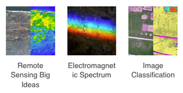 Remote Sensing
 Remote sensing entails the study of the Earth from a higher vantage point. With the aerial perspective, we can take a closer look at the local environment.
Educational Activities Archives
 Citizen Science
 Overview of a variety of Citizen Science Programs including: The GLOBE Program; CoCoRaHS; Clean Water Hub; and the AREN Project.
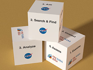 Data Literacy
 NASA's Data Literacy Cubes are educational tools that use a physical cube with questions on each face to guide students through analyzing NASA Earth science data, such as graphs, maps, and data tables. These cubes are designed to help students develop data analysis and interpretation skills by connecting to leveled question sheets, enabling differentiated instruction for learners of varying levels.
 AREN Student Research Projects
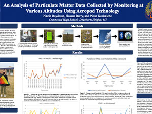
 High school students from Crestwood High School in Dearborn Heights, Michigan, conducted science research projects using materials provided by the AREN Project and submitted their work to either the GLOBE International Virtual Science Symposium or the GLOBE Student Research Symposium. Their projects included An Analysis of Particulate Matter Data Collected by Monitoring at Various Altitudes Using Aeropod Technology, Use of a TerraRover 2 to Collect Fine Particulate Matter Using Arduino Related Technology, Assessing the Effects of Surface Temperature and Tree Coverage in Select Suburban Parks, and TerraRover 2 Augmented to Detect a Suite of Atmospheric Parameters Using Arduino Related Technology.
 Creating a Green Leaf Index with ArdGIS Pro
 In this exercise, we will use QGIS to apply a formula to a georeferenced image that uses the values contained in the image's pixels to create a new image that identifies likely green vegetation. We will then modify the style (or symbology) of the resulting image to better see our results. Note: You will need a georeferenced image to complete this tutorial. Georeferencing is the process of adding real-world coordinate information to an image so that it can be used in mapping software. You can produce your own georeferenced image with the separate AREN Georeferencing with ArcGIS Pro Tutorial.
 Georeferencing an Aerial Image with ArcGIS Pro
 In this exercise, we'll georeference an aerial image from an Aeropod by assigning it real-world spatial coordinates. Unlike simply marking where the image was taken, georeferencing aligns the image with actual ground locations, allowing it to be combined with other geographic data in Geographic Information System (GIS) software and analyzed quantitatively. ArcGIS Pro is a GIS tool for processing and analyzing spatial datasets using layers and analysis tools. ArcGIS Pro requires the Windows operating system and a license for use.
 Green Leaf Index with QGIS and an Aerial Image
 In this exercise, we will use QGIS to apply a formula to a georeferenced image that uses the values contained in the image's pixels to create a new image that identifies likely green vegetation. We will then modify the style (or symbology) of the resulting image to better see our results.
Note: You will need a georeferenced image to complete this tutorial. Georeferencing is the process of adding real-world coordinate information to an image so that it can be used in mapping software. You can produce your own georeferenced image with the separate AREN Georeferencing with QGIS tutorial.
QGIS is an open-source GIS tool for processing and analyzing spatial datasets using layers and analysis tools. QGIS is available for Windows, macOS, ChromeOS, and Linux operating systems.